Larocque East
Overview
Location
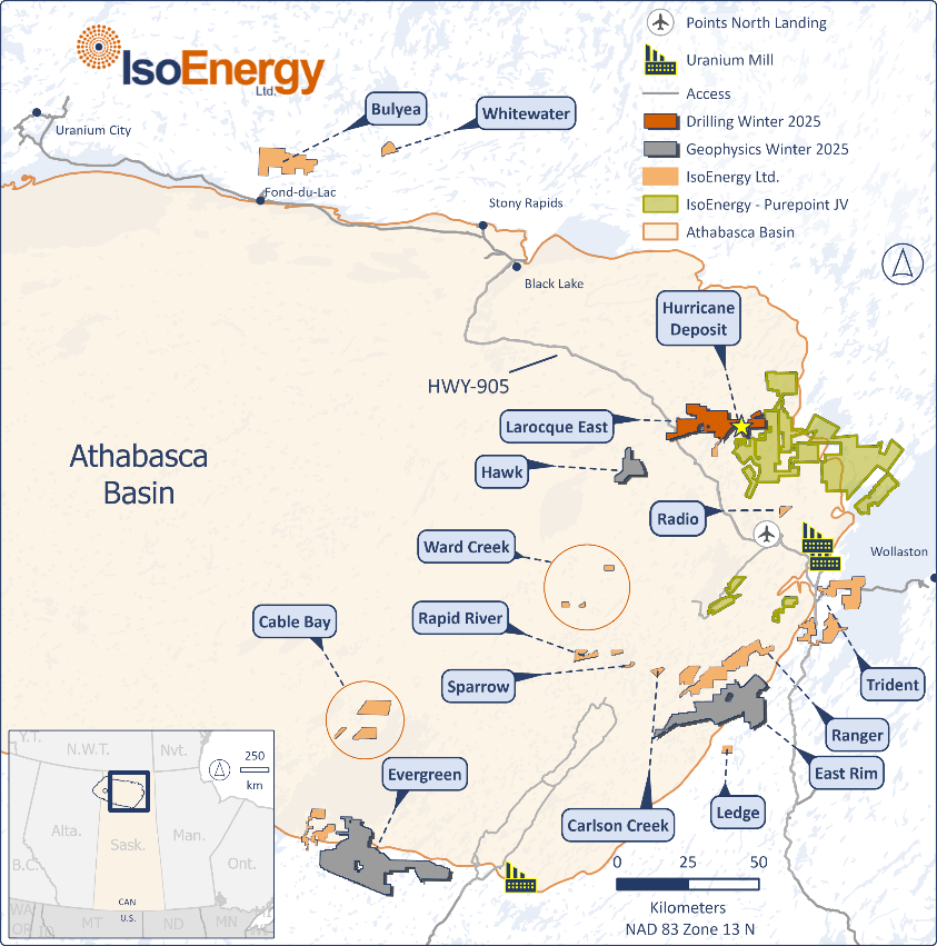
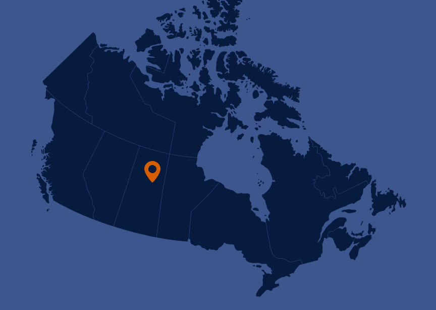
Eastern Athabasca Basin, SK, Canada
Ownership
100% IsoEnergy
Deposit Type
Unconformity sandstone hosted uranium
Stage
Potential Development
Primary Minerals
Uranium
Highlights
- 39 mineral claims totaling 19,699 hectares
- Very high-grade mineralization over widths and thicknesses seen at major deposits – up to 12m thick x 125m wide
- Shallow depth of 325m with no water cover at surface
- Located near roads and power in the Eastern Basin, Orano’s McClean Lake mill only 40km away
- Innovation taking place around new, lower-cost mining techniques for unconformity hosted uranium deposits
- Cameco/Orano Dawn Lake JV adjacent to Hurricane – exploration being undertaken on that property
Technical Reports
Mineral Resource Estimate (2022)
| U308 Resources | ||||
|---|---|---|---|---|
| Category | Domain | Tonnes (000 t) | grade (%) | Contained (Mlbs) |
| Indicated | High Grade | 38.2 | 52.1% | 43.9 |
| Medium Grade | 25.6 | 8.4% | 4.7 | |
| Low Grade | - | - | - | |
| Total Indicated | 63.8 | 34.5% | 48.6 | |
| Inferred | High Grade | - | - | - |
| Medium Grade | 4.0 | 11.2% | 1.0 | |
| Low Grade | 50.3 | 1.5% | 1.7 | |
| Total Inferred | 54.3 | 2.2% | 2.7 | |
|
1. CIM (2014) definitions were followed for all Mineral Resource categories. For additional information regarding the Larocque East project please refer to the Technical Report entitled “Technical Report on the Larocque East Project, Northern Saskatchewan, Canada” dated July 12, 2022 prepared by SLR Consulting (Canada) Ltd., available under IsoEnergy’s profile on www.sedarplus.ca. The “qualified person” for this technical report is Mark B. Mathisen, C.P.G., Principal Geologist, SLR Consulting International Corp. Mr. Mathisen is a “qualified person” under NI 43-101. |
||||
Geology
Larocque East was purchased in May 2018 and subsequently expanded through staking. The property covers a 15-kilometre-long northeast extension of the Larocque Lake conductor system; a trend of graphitic metasedimentary basement rocks that is associated with significant uranium mineralization in several occurrences to the southwest of the Larocque East property. The closest of these are the Larocque Lake and Larocque North zones, which are located 6.5 kilometres and 0.4 kilometres, respectively, to the southwest of the western Larocque East property boundary. Drilling at the Larocque Lake zone has returned historic intersections of up to 29.9% U3O8 over 7.0 metres in drill hole Q22-040. Drilling at the Larocque North zone has returned intersections of up to 2.05% U3O8 over 0.8 metres in drill hole Q22-16.
Larocque East is located adjacent to the Wollaston-Mudjatik transition zone - a major crustal suture related to most of the major uranium deposits in the eastern Athabasca Basin. Importantly, the sandstone cover is thin, ranging between 140 metres and 330 metres in previous drilling. A total of 42 historical drill holes have been completed on the property along approximately 22 kilometres of graphitic conductors. Five historical drill holes have intersected weak uranium mineralization on the Larocque East property to date, including drill holes KER-07 (0.12% U3O8 over 0.1 metre) and KER-11 (0.06% U3O8 over 0.5 metre) near the western property boundary, within the general vicinity of 2018 discovery drill hole LE18-01A.
Exploration Potential
- 2025
- 2024
- 2023
- 2022
- 2021
- 2020
- 2019
- 2018
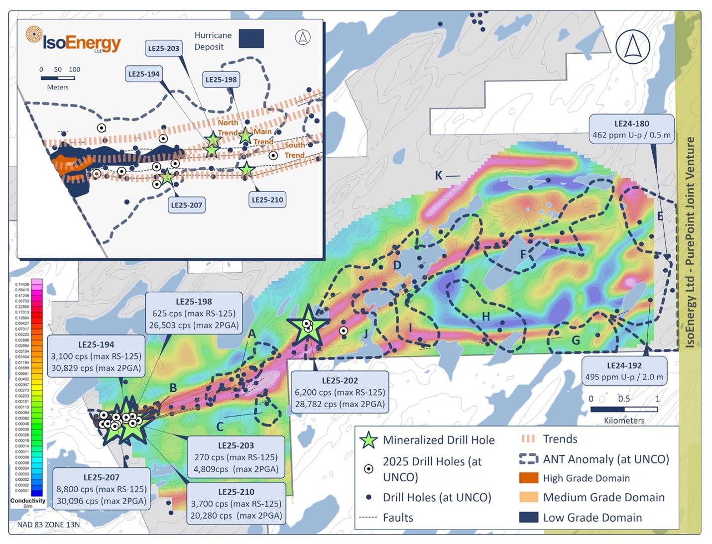
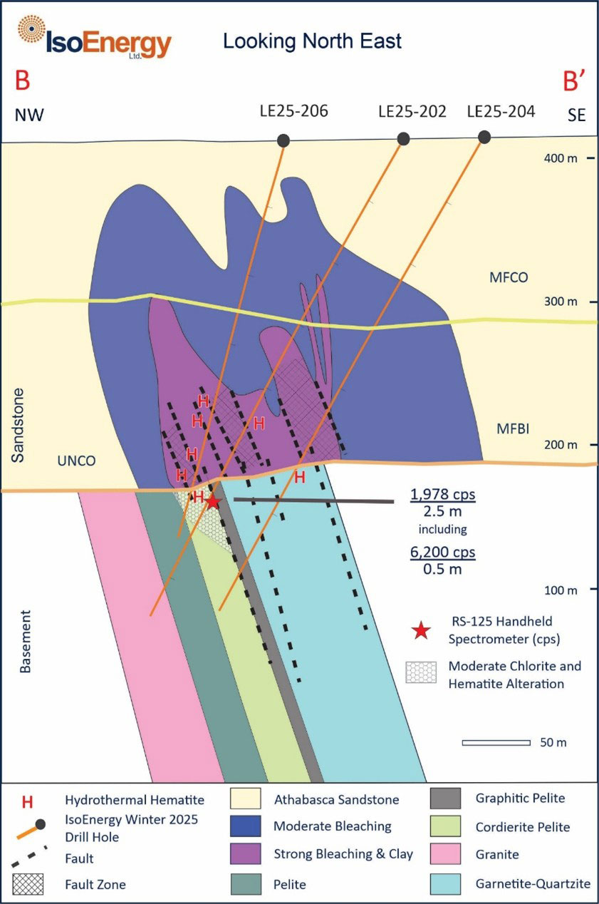
A 6,396m winter drill program comprising 17 holes was completed in early 2025 at the Larocque East project, targeting extensions of the Hurricane deposit and new zones to the east along the Larocque Trend. Drilling intersected elevated radioactivity in five holes, confirming structural continuity along key fault corridors and supporting the potential for deposit expansion. At Area D, located 2.8 km east of Hurricane, hole LE25-202 returned the strongest radioactivity encountered to date outside the main deposit, averaging 6,200 cps over 0.5m.
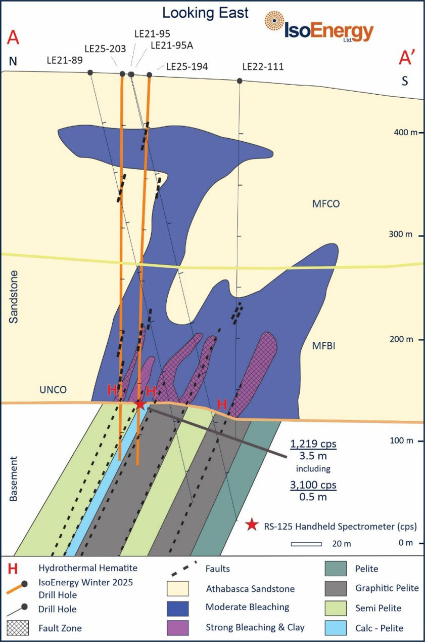
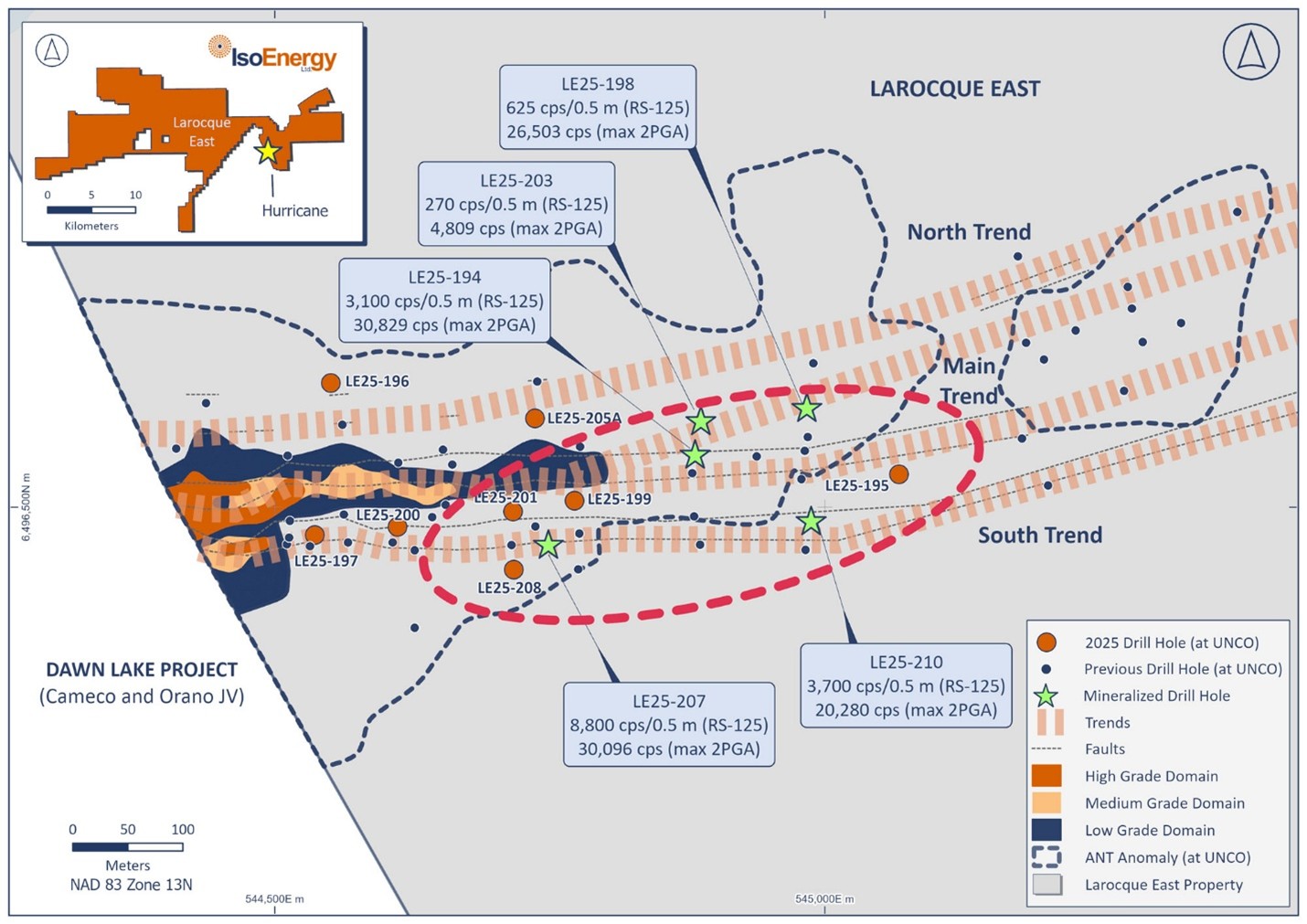
Results from holes LE25-194 and LE25-207—drilled 80m and 240m east of Hurricane, respectively—revealed significant radioactivity associated with the Main and South trends. These intercepts, combined with confirmation of graphitic basement lithologies and alteration zones, further validate the corridor’s mineralizing potential and the presence of a regional-scale hydrothermal system. All core samples have been submitted for geochemical analysis, with assays pending.
A follow-up summer drill program is now underway across the eastern Athabasca Basin uranium properties. The campaign includes 20 holes for 7,600 to continue testing the potential of the Hurricane Main and South trends, as well as the Greenfield Targets E, F, and K, where summer 2024 work identified prospective unconformities.
A 3,150m winter drill program comprising six holes in early 2024 tested two targets (Areas A and B) east of the Hurricane deposit along the conductor corridor. Drilling intersected brittle faults, alteration zones, and graphitic-pyritic basement lithologies up to 2,200m east. Results from the program, combined with the Ambient Noise Tomography (ANT) survey, confirmed a large hydrothermal system, a key indicator of unconformity uranium deposits in the Athabasca Basin.
A 27-hole, 8,775m summer drill campaign commenced to follow up on the significant basement structures and clay alteration halos observed in Area A, while also testing new targets in Areas B, C, and D. An expanded ANT survey identified six high-priority drill targets (Areas E–J) east of Hurricane. Drilling in Areas A, B, and D confirmed a strong correlation between low-velocity ANT anomalies and structural disruption, reinforcing the Hurricane corridor’s potential for further uranium mineralization.
By November 2024, the program was expanded with 30 holes totaling 13,015m along the Larocque Trend. High-priority zones were identified in Areas D and E, with notable uranium intersections, while results from Hurricane East and Area B suggest expansion potential. With 33% of geochemical results received, strong hydrothermal alteration and elevated uranium pathfinders indicate continued potential. Follow-up drilling planned for January 2025 will further test high-priority targets.
A program of 1,909m in 6 drill holes was completed in March 2023. Drilling followed up favourable results identified in summer of 2022. Drill hole LE23-146 is the highlight of the winter program and intersected significant basement alteration consisting of hydrothermal hematite and clay that is associated with uranium mineralization in Athabasca Basin.
A program of 2,175m in 6 drill holes was completed at Larocque East. Four holes were dedicated to expansion of Hurricane. Drill hole LE23-155 targeted the unconformity 26.5m west of drill hole LE21-78c1 and intersected 8.5m averaging 4.1% U3O8 between 325.0 to 333.5m downhole, which includes an intercept of 6.8% U3O8 over a 1.0 m interval from 327.0 to 328.0m and includes a higher-grade interval of 23% U3O8 over 1.0 m from 331.5 to 332.5m. Additionally, a single hole was completed to test resistivity targets north of Hurricane. The drill hole added valuable knowledge in understanding the geology of the project area.
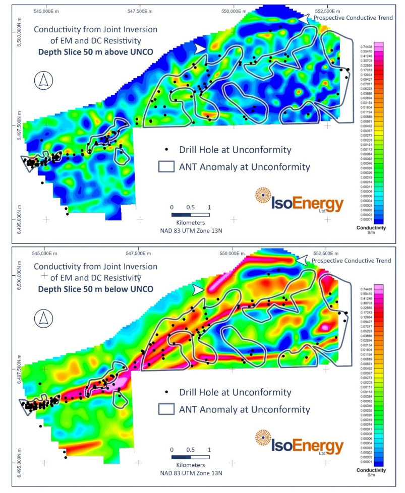
An Innovative Ambient Noise Tomography (ANT) survey was completed on the Larocque East in collaboration with FLEET. The ANT survey successfully detected a significant low velocity feature coincident with the known Hurricane alternation. It also identified a compelling 1-kilometre-long ANT target along strike of the Hurricane deposit with the same footprint as the feature associated with Hurricane.
A program of 12,147m in 30 drill holes was completed in March 2022. The primary goal of the program was to systematically test Larocque Lake conductive trend. Five drill holes were planned to test proximal to Hurricane zone for potential southern expansion. Drilling intersected significant alteration and structure in several holes including in hole LE22-115A 2.0 m @ 1.03% U3O8, including 0.5m @ 3.26% U3O8.
A program of 1,998m in 6 drill holes was completed in July 2022. Three drill holes tested anomalous sandstone geochemistry within two kilometers of Hurricane deposit and one hole tested underexplored section of the Larocque trend in the eastern portion of the project. The remaining two drills holes were planned to follow-up anomalous geochemistry intersected in historical drilling on the Kernaghan trend.
A program of 12,694m in 30 drill holes was completed in November 2021. The drilling campaign had three main objectives: expansion of Hurricane zone, infill drill to test the continuity of the high-grade mineralization, and exploration of areas east of Hurricane. Drilling intersected mineralization in several holes, including:
- LE21-107: 6.5m @ 20.4 U3O8, including 3.5m @ 34.5% U3O8.
- LE21-78C1: 12m @ 5.2 U3O8, including 2.0m @ 27.6% U3O8.
- LE21-87A: 7.5m @ 4.5 U3O8, including 2.0m @ 9.2% U3O8.
A program of 10,325m of core drilling in 24 drill holes was completed in March with two drills. One drill rig concentrated on the western end of the Hurricane zone footprint, expanding the mineralization west to the property boundary. A second drill rig began evaluating the potential for additional uranium mineralization well to the east (200m to 1,600m) of the Hurricane zone footprint. Both of these efforts were successful.
Western Hurricane Zone Expansion
All 14 drill holes completed were mineralized. Further, a new zone characterized by very high-grade mineralization over thick intervals was intersected in several drill holes. The best example is drill hole LE20-34, which intersected 33.9% U3O8 over 8.5m, including 57.1% U3O8 over 5.0m. All five of the westernmost sections remained open for expansion to the north and/or to the south.
Eastern Potential
Drilling to the east of the Hurricane zone evaluated the western portion of a 5km long basement conductive zone mapped by the 2019 DC-resistivity survey. Strongly graphitic basement gneisses hosting brittle faults were intersected in all the widely spaced reconnaissance drill holes completed up to 1.6km east of the Hurricane zone during the winter program. Several of these drill holes also intersected significant sandstone alteration with elevated sandstone uranium geochemistry and/or illitic clay alteration.
A program of 9,578 metres in 24 drill holes was completed in October 2020, with many outstanding intersections obtained as the footprint expanded, including:
- LE20-76: 7.5m @ 38.8% U308, including 3.5m @ 74.0% U3O8
- LE20-72: 6.0m @ 6.2% U308, including 1.5m @ 20.7% U3O8
- LE20-68: 11.0m @ 6.9% U308, including 1.5m @ 49.3% U3O8
- LE20-64: 5.0m @ 48.8% U308 including 4.0m @ 57.5% U3O8
- LE20-62: 4.5m @ 6.2% U308 including 2.5m @ 11.1% U3O8
- LE20-57: 10.0m @ 11.7% U308 including 2.5m @ 46.0% U3O8
- LE20-54: 9.0m @ 12.8% U308 including 4.0m @ 27.1% U3O8
The first follow-up drilling program was completed in the winter (January to March). The program was very successful with 11 of 12 drill holes intersecting significant uranium mineralization.
Highlights include:
- LE19-02: 3.5m @ 10.4% U3O8,
- LE19-03: 3.0m @ 2.7% U3O8, 2.3% Ni,
- LE19-06: 4.0m @ 3.8% U3O8,
- LE19-09: 4.5m @ 4.2% U3O8, 1.1% Ni, 0.8% Co
- LE19-12: 8.5m @ 3.2% U3O8 and 2.1% Ni
Following the winter drilling campaign, the Hurricane zone was open for expansion on most sections, along-strike in both directions, and measured 150 metres long, 40 metres across and up to 10 metres thick.
Drilling resumed in the summer of 2019 with a 17-drill hole campaign designed primarily to evaluate the potential for expansion along-strike to the east of the winter drilling. This program was also successful, with the best intersection to date being obtained from drill hole LE19-16A (7.0m @ 5.4% U3O8, 0.7% Ni and 0.1% Co). Drill holes LE19-18 (3.0m @ 1.5% U3O8) and LE19-18C1 (5.0m @ 1.2% U3O8) successfully extended high-grade uranium mineralization 100 metres to the east.
This was followed by a large, 250m further step-out to the historical drill hole KER-07 section. Weak uranium mineralization in drill hole LE19-22 successfully extended the Hurricane zone footprint to 500 metres long. A 40-metre gap on-section between drill holes LE19-22 and KER-07 may contain significant uranium mineralization. The next large step-out section 200m along-strike to the east was begun with drill hole LE19-26. Intended to be a stratigraphic drill hole angled beneath the Hurricane zone target area, LE19-26 encountered a thick zone of sandstone alteration and structure characterized by elevated trace element geochemistry and radioactivity. All of this occurs well north of the expected trace of the Hurricane zone. The drill hole is located on the western edge of a prominent basement DC-resistivity low anomaly that extends to the east for several kilometres, likely indicating the presence of highly graphitic basement rocks – the preferred host for uranium deposits in the Athabasca basin.
The Hurricane zone was discovered by drill hole LE18-01A, IsoEnergy’s first ever drill hole at Larocque East. Drill hole LE18-01A intersected a broad, 8.5-metre-long interval of elevated radioactivity averaging 1.26% U3O8 and includes a higher-grade subinterval of 3.58% U3O8 over 2.5 metres. Within the higher-grade subinterval is a zone of off-scale radioactivity (>15,000 cps on an SRAT SPP2 scintillometer (the “SPP2”)) that averages 6.45% U3O8 over 1.0 metre.
Technical Maps
Location of winter 2025 drill holes with respect to the Hurricane resource footprint (blue) and the ANT seismic low velocity zone in which the Deposit occurs, and projected Hurricane mineralization-controlling fault zones. RS-125 values are highest averages over 0.5 metre intervals.
Compilation map of Larocque East project showing the Hurricane deposit, winter 2025 and summer 2024 drill hole locations and ANT seismic velocity anomalies (A though J) on a plan view of the 2025 conductivity model 50 metres below the unconformity. 20 drill holes planned for the summer will test targets at Hurricane, in target areas D, E and F, and at the untested northern conductive trend (Target K)
