Overview
Location
Québec, Canada (Otish Mountain Sedimentary Basin)
Ownership
100% IsoEnergy
Deposit Type
Uraninite-veins within a broader alteration envelope and with significant uranium mineralization at the unconformity
Stage
Potential Development
Primary Minerals
Uranium
Highlights
- High-Grade and Substantial Historic Resources
- The Matoush Fault Zone, the structure that controls the mineralization, has been identified over a strike length extending 11km southward and 2.5km northward beyond the historic resource area. In addition, many of the zones of mineralization within the historic Mineral Resource are open along strike and down plunge.
- Quebec ranks highly as a mining jurisdiction and has seen significant past expenditures on uranium exploration by both major and junior mining companies.
Historical Mineral Resource Estimate:
| Category | Tonnes (M) | Grade (% U3O8) |
Contained (M lbs) |
|---|---|---|---|
| Indicated | 0.6 | 0.954 | 12.3 |
| Inferred | 1.7 | 0.442 | 16.4 |
Notes:
1. CIM definitions were followed for the Historic Estimate.
2. The Historic Estimate was estimated at a cut-off grade of 0.1% U3O8.
3. The Historic Estimate was estimated using an average long-term uranium price of US$75 per pound.
4. A minimum mining width of 1.5 m was used.
5. The MT34A lens is within both the MT-34 and AM-15 zones.
6. Numbers may not add due to rounding
For additional information regarding the Matoush Project, please refer to the Technical Report entitled “Technical Report on the Mineral Resource Update for the Matoush Project, Central Québec, Canada” dated February 12, 2012, prepared by Roscoe Postle Associates Inc. (“RPA”). The Mineral Resource estimate was further updated by RPA in December 2012, as disclosed in a press release of Strateco dated December 7, 2012.
This resource is a historical estimate under National Instrument 43-101 – Standards of Disclosure for Mineral Projects ("NI 43-101") and a qualified person has not done sufficient work to classify the historical estimate as current mineral resources. As a result, the historical estimate is not being treated as a current mineral resource.
Geology
Mineralization at Matoush is similar to Athabasca unconformity type uranium deposits with regard to its occurrence in Proterozoic sedimentary rocks exhibiting similar alteration styles and structural controls. A notable divergence in the nature deposit at Matoush from the typical Athabasca style deposit is the lack of uranium mineralization at the actual unconformity. Uranium mineralization at Matoush occurs primarily in relatively flat lying accumulations between 150m and 600m above the basement unconformity within Indicator Formation Sandstones where they are breeched by structures. The penetrating structures have acted as conduits for the flow of mineralizing fluids and are often themselves associated with more steeply dipping zones of mineralization. It should be noted that mineralization is consistent with and roughly the same age as the Westmoreland Uranium project located in Queensland Australia.
The Matoush uranium mineralization occurs within a much broader alteration envelope and is characterized by replacement style disseminations and clots of fine-grained uraninite plus, in the higher-grade areas, semi-massive veins of uraninite.
Exploration Potential
Planned 2025 Work
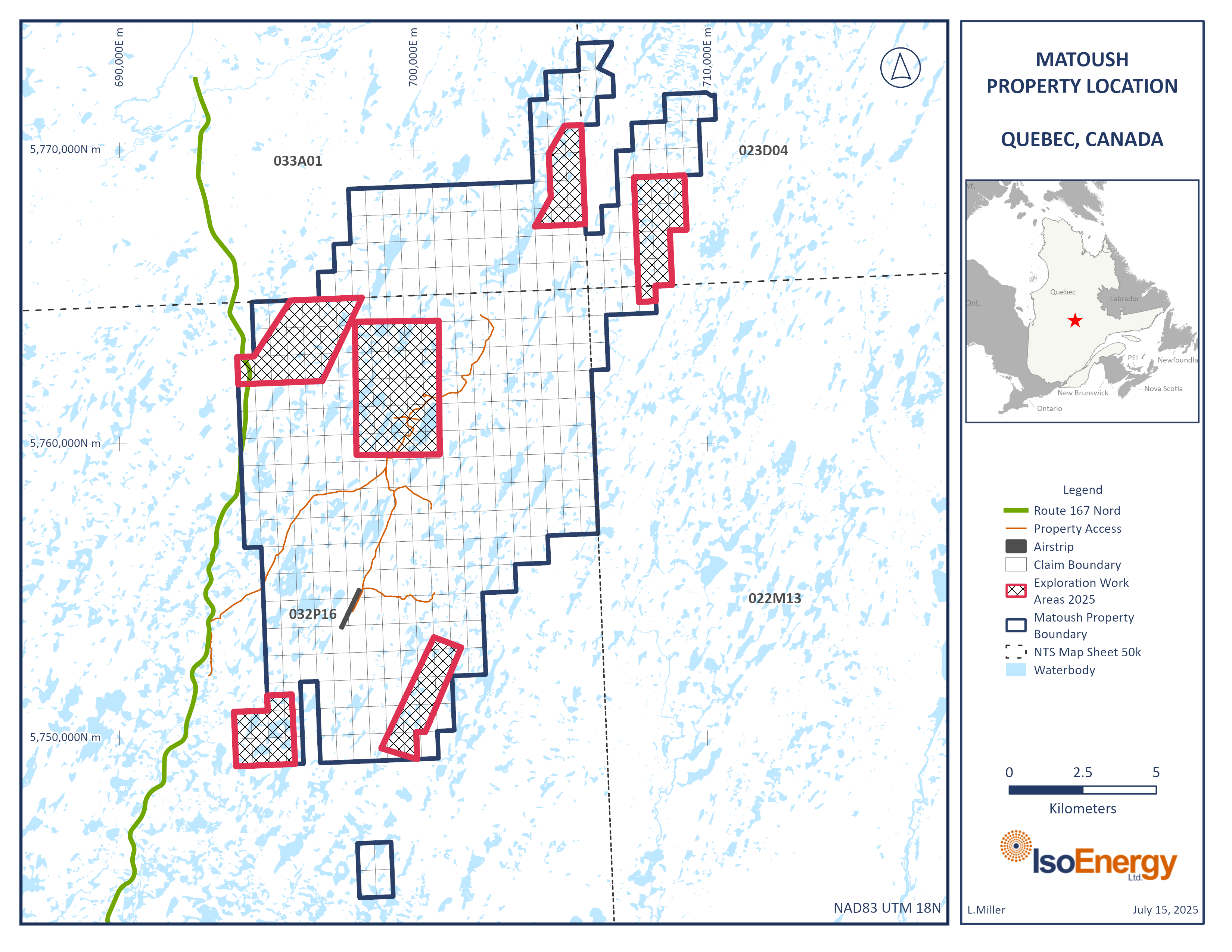
A non-impact-causing exploration work program is scheduled for August–September 2025. This will include 1) ground-based magnetic and VLF-EM (very low frequency electromagnetic) geophysical surveys, and 2) a biogeochemical survey on black spruce trees, collecting approximately 500-1000 samples. A helicopter will be used for less than 10 days to reach selected remote locations. The project work will take place in discrete areas within a 100 km2 area as shown in Figure 1. The work crew will vary between 10-16 workers. More information is provided in the Exploration Work Annual Planning 2025 and the Information Session Summary.
The Matoush project is located in the Otish Mountains of the prolific mining region of Quebec, Canada, 210 km north of the Cree community of Mistissini and approximately 275 km north of the town of Chibougamau. The Property currently comprises 407 mining claims covering a total area of 21,595 hectares. The overall project area extends ~24 kilometers from north to south and up to 12 kilometers in width. Quebec is known as a proven mining jurisdiction with significant uranium endowment.
The Matoush project has seen extensive exploration, evaluation and permitting activities. Such activities have included the construction of a 50-person camp, a landing strip for planes carrying material and passengers and three megadomes and offices. Additionally, approx. 245k meters of drilling was completed in 591 holes. Structures previously installed by a past operator have been removed. Drill cores remain stored on-site in core racks and sea cans, alongside a few small wooden buildings historically used for core logging and sampling. Several technical and environmental studies were completed by the past operator. In 2008, an initial Preliminary Economic Assessment (PEA) was conducted, which was subsequently updated in 2010. Multiple mineral resource estimates have been completed, with the latest being conducted in December 2012. Numerous environmental studies have been conducted, making up an Environmental Impact Statement (EIS).


