Overview
Location
Utah, United States (White Canyon, Colorado Plateau)
Ownership
100% IsoEnergy
Deposit Type
Tabular sandstone-hosted
Primary Minerals
Uranium
Stage
Past-producing
Proximity to White Mesa Mill
70 mi (113 km)
Highlights
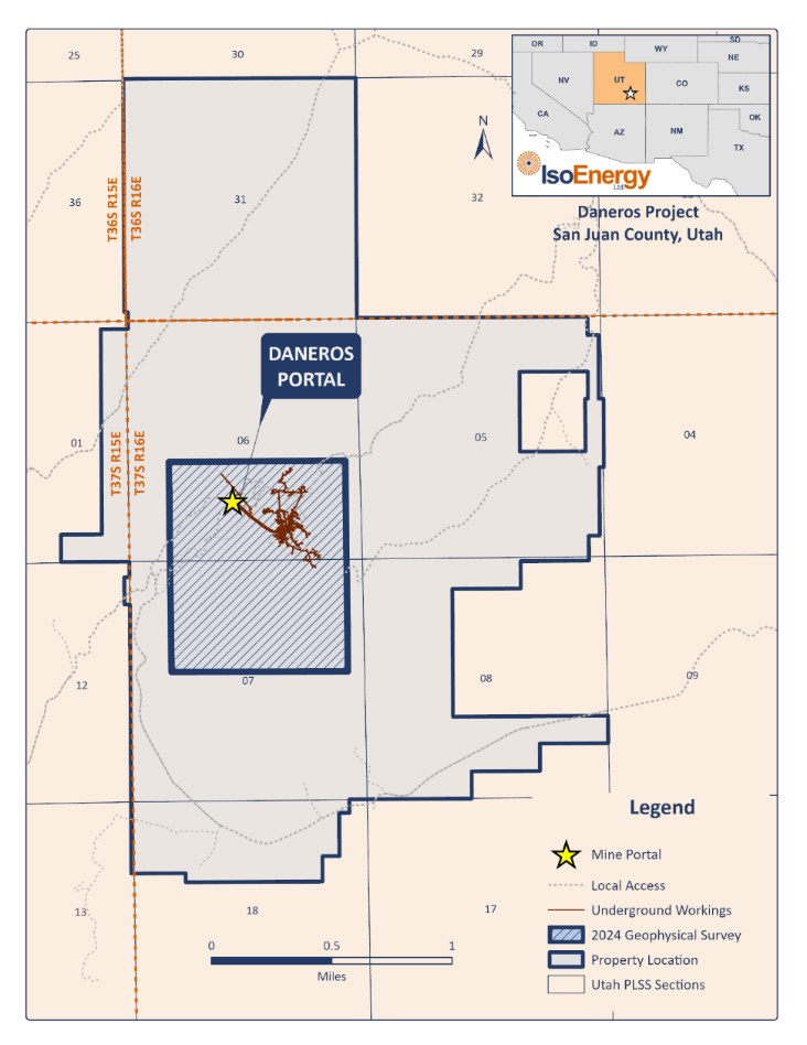
- Daneros Mine is a fully-developed and permitted underground mine located in the White Canyon Mining district in San Juan County, Utah, Approximately 70 miles west of the White Mesa Mill
- It was acquired by Denison Mines in 2011 as part of the White Canyon takeoverfor A$57m
- The mine operated from 2009 until October 2012 when it was placed on standby
- Initially White Canyon Uranium Limited brought the mine into production sending ore to the White Mesa Mill under a toll milling agreement with Denison. Energy Fuels acquired the mine in 2012
Historical Mineral Resource Estimate:
| Category | Tonnes (000s) | Grade (% U3O8) |
Contained (000s) |
|---|---|---|---|
| Indicated | 20 | 0.36 | 142 |
| Inferred | 7 | 0.37 | 52 |
Notes:
1) Mineral Resources were classified in accordance with CIM Definition Standards.
2) Mineral Resources are estimated at a cut-off grade of 0.23% eU 3 O 8 .
3) Mineral Resources are estimated using a long-term uranium price of $55 per pound U 3 O 8 .
4) A minimum thickness of 1 foot was used.
5) Bulk density is 0.07143 ton/ft3 (14 ft3/ton).
6) Mineral Resources are exclusive of Mineral Reserves and do not have demonstrated economic viability.
7) Numbers may not add due to rounding.
For additional information on the Daneros Mine, please refer to the Technical Report entitled “Updated Report on The Daneros Mine Project, San Juan County, Utah, U.S.A." dated March 2018, prepared by Peters Geosciences.
This resource is a historical estimate under National Instrument 43-101 – Standards of Disclosure for Mineral Projects ("NI 43-101") and a qualified person has not done sufficient work to classify the historical estimate as current mineral resources. As a result, the historical estimate is not being treated as a current mineral resource.
Historical Production:
| Project | Tons (000s) | %U3O8 | lbs U3O8 (000s) |
|---|---|---|---|
| Daneros (2010-2013) | 120 | 0.26 | 628 |
| Other Mines1 | 73 | 0.22 | 314 |
1Other Mines include the Cove (Lark), Bullseye and Spook former mines. These former mines are located on claims obtained as part of the Transaction.
Geology
Major uranium deposits in the White Canyon District occur at or near the base of the Upper Triassic Chinle Formation, in fluvial channel deposits of the Shinarump Member, the basal member of the Chinle Formation. Uranium mineralization appears to be related to low-energy depositional environments in that uranium is localized in fluvial sandstones that lie beneath organic-rich lacustrine-marsh mudstone and carbonaceous delta-front sediments.
Exploration Potential
Significant drilling occurred in 2007 and 2008 to confirm historical resources. There is potential for additional resources, as indicated by historical mineral resources at the Lark and Royal. Higher-grade mineralization occurs in paleochannels that are more than 20 ft. thick. Identifying and targeting these areas may lead to discovery of further mineralization.
Five combined conventional rotary and core holes, totaling 2,280 feet, were drilled at the Daneros Mine in early 2023 to further evaluate the presence of strong uranium mineralization. Each of the five holes completed encountered significant uranium mineralization within the targeted host rocks of the Shinarump Member of the Chinle Formation.
The results obtained from the 2023 Daneros drilling program continue to confirm that the continuity, thickness and overall grade characteristics of the uranium mineralization at the Daneros Mine. The grades, thicknesses and host rock characteristics, as shown in the results, are consistent with the nature and extent of uranium mineralization of the White Canyon mining district, which has been one of Utah's most important uranium producing areas.
2024 exploration activities include an initial 8 line-kms of orientation seismic surveys over the known uranium mineralization. Results from the geophysical surveys, sedimentological mapping and historic exploration data are expected to be integrated to define new exploration targets for subsequent drill testing in Q4.


