Overview
Location
Utah, United States (Henry Mountain Basin, Colorado Plateau)
Ownership
100% IsoEnergy
Deposit Type
Tabular sandstone-hosted
Stage
Past-producing
Proximity to White Mesa Mill
127 mi (204 km)
Highlights
- Tony M Mine is a large-scale, fully-developed and permitted underground mine located in the Henry Mountain Basin 5 miles north of Ticaboo, Utah and 127 miles west of the White Mesa Mill
- It has excellent surface facilities and 17 miles of existing underground development. There is little refurbishment expected to be needed to bring it into production
- The mine was originally developed by Plateau Resources Ltd. in the late 1970s
- Most recently operated by Denison Mines Corp. from September 2007 to November 2008 and acquired by Energy Fuels in 2012
- The mine has been maintained in a ready state with all required permits in place to resume operations
Mineral Resource Estimate:
| Category | Tonnes (M) | Grade (% U3O8) |
Contained (M lbs) |
|---|---|---|---|
| Indicated | 1.1 | 0.28 | 6.6 |
| Inferred | 0.4 | 0.27 | 2.2 |
|
Notes: For additional information regarding the Tony M mine, including the mineral resource estimate, please refer to the Technical Report entitled “Technical Report on the Tony M Mine, Utah, USA – Report for NI 43-101” with an effective date of September 9, 2022 prepared by SLR Consulting (Canada) Ltd., available on www.sedarplus.ca. The “qualified person” for this technical report is Mark B. Mathisen, C.P.G., Principal Geologist, SLR Consulting International Corp. Mr. Mathisen is a “qualified person” under NI 43-101. |
|||
Historical Production
| Operator | Period | Tons Produced (st) |
Average Grade %U3O8 |
Contained Metal (lbs U3O8) |
|---|---|---|---|---|
| Plateau | Sept. 1979 to April 19841 | 237,000 | 0.121 | 574,500 |
| Denison | Sept. 2007 to Dec 2008 | 94,100 | .0165 | 310,500 |
| Total Mined Out | 331,100 | 0.134 | 885,000 |
Notes:
- Includes 72,359 st at 0.91% eU3O8 (131,647 lb eU3O8) from stockpiled material shipped to White Mesa by Denison 2007-2008.
Geology
Tabular sandstone-hosted uranium deposits present in the lowermost sandstones of the Salt Wash Member of the Jurassic age Morrison Formation. Mineralization primarily consists of coffinite, with minor uraninite, which usually occurs in close association with vanadium mineralization.
Exploration Potential
The property hosts the Tony M and Southwest uranium deposit and strong exploration potential exists in direct proximity to the Tony M mine.
- 2026
- 2025
- 2024
- 2023
- 2022
In late 2025 and into 2026, IsoEnergy initiated a bulk sample program targeting up to ~2,000 tons of mineralized material from existing workings. This program is expected to generate real-world mining and processing data through the White Mesa Mill, supporting a potential production restart decision and informing final operating assumptions.
Following the completion of rehabilitation and mapping, IsoEnergy advanced its technical work in 2025, progressing studies to better define potential production parameters, including operating and capital considerations, marking another step toward near-term production.
Over 2024-2025, IsoEnergy completed a comprehensive program to rehabilitate underground workings, upgrade site infrastructure, and de-risk key economic drivers.
Technical initiatives, including ore sorting, high-pressure slurry ablation testing, and evaporation optimization, focused on lowering operating costs and strengthening the project's overall economics. Completed beneficiation test work demonstrated greater than 90% uranium recovery. High-pressure slurry ablation upgraded material to approximately 25% of original mass, while ore sorting achieved greater than 90% recovery into roughly 50% mass for amenable material.
The Enhanced Evaporation Study confirmed that Landshark evaporators can eliminate the need for evaporation pond expansion, reducing permitting timelines and capital requirements.
As part of its 2025 U.S. exploration program, IsoEnergy initiated an initial drill campaign at the Flatiron Project, located approximately seven miles northwest of the Tony M Mine in Utah's Henry Mountains uranium district. The program consists of approximately 15,000 feet of drilling, designed to follow up on historic regional exploration conducted in the early 1980s and systematically test high-priority targets along trend with known mineralized systems.
As announced on February 29, 2024, IsoEnergy made the strategic decision to reopen underground access at the Tony M Mine with the goal of restarting uranium production. On July 26, 2024, the main decline at Tony M was successfully reopened, marking a major milestone toward this objective.
Initial inspections of the underground conditions have been encouraging, with the main decline and underground equipment shops in good shape. Rehabilitation work is now underway, led by Tomcat Mining, and includes ground scaling, installation of support systems, and ventilation upgrades. This phase is expected to take 8 to 10 weeks, depending on ground conditions.
IsoEnergy has engaged top-tier consultants to support this process. SRK Consulting is leading the design and implementation of the ventilation plan, while Call & Nicholas is overseeing the ground control strategy. As sections of the mine are made safe, the geology team will begin underground mapping, including a LiDAR survey.
The Company completed 21 of the up to 59 proposed combined conventional rotary and core holes, for approximately 16,240 feet of drilling. The 2023 program was designed to increase the density of drill holes, in order to upgrade “Inferred” mineral resources (as determined by the SLR International Corporation in their 2022 Technical Report on the Tony M project) to the “Indicated” mineral resource category and develop a detailed understanding of the distribution of vanadium mineralization in the deposit. Historically, there has been very little investigation of the vanadium potential at Tony M. Confirmation drill program in 2022 showed V2O5/U3O8 ratio ranges from an average of 1:1 to greater than 17:1 at various localities that within the mine area.
The surface rotary and core drilling program was designed to confirm the results of previous drilling carried out by Plateau Resources, who were the original discoverers and developers of the Tony M Mine.
The 2022 drilling program was designed to confirm the stratigraphic position of uranium mineralization, the relative thicknesses of mineralized intervals, and the range of uranium grades that were encountered in the historical drill holes. The drill program was comprised of eight combined conventional rotary and core holes with vertical orientation, totaling 2,894 feet. Core samples from the drilling were assayed for uranium and vanadium, although 7 a very limited amount of historical data exists for vanadium. The program successfully verified the historic drill results as accurate and true for resource estimation. Eight holes were drilled with a tri-cone rotary method (“conventional open-hole”) to the top of the lower rim of the Salt Wash sandstone unit, approximately 400 feet from surface. The rotary drill cuttings were collected at 5-foot intervals and the lithologies were recorded by Company personnel. When the core point was reached (the top of the target horizon) a traditional 3-inch core barrel was placed on the drill string to core the entire Lower Rim of the Salt Wash sandstone. The zones that were cored in 20-foot-long intervals and were measured and marked by Company personnel and logged for lithology, geotechnical properties, and mineralization. The core boxes were stored in a locked warehouse on the Tony M property.
Technical Maps
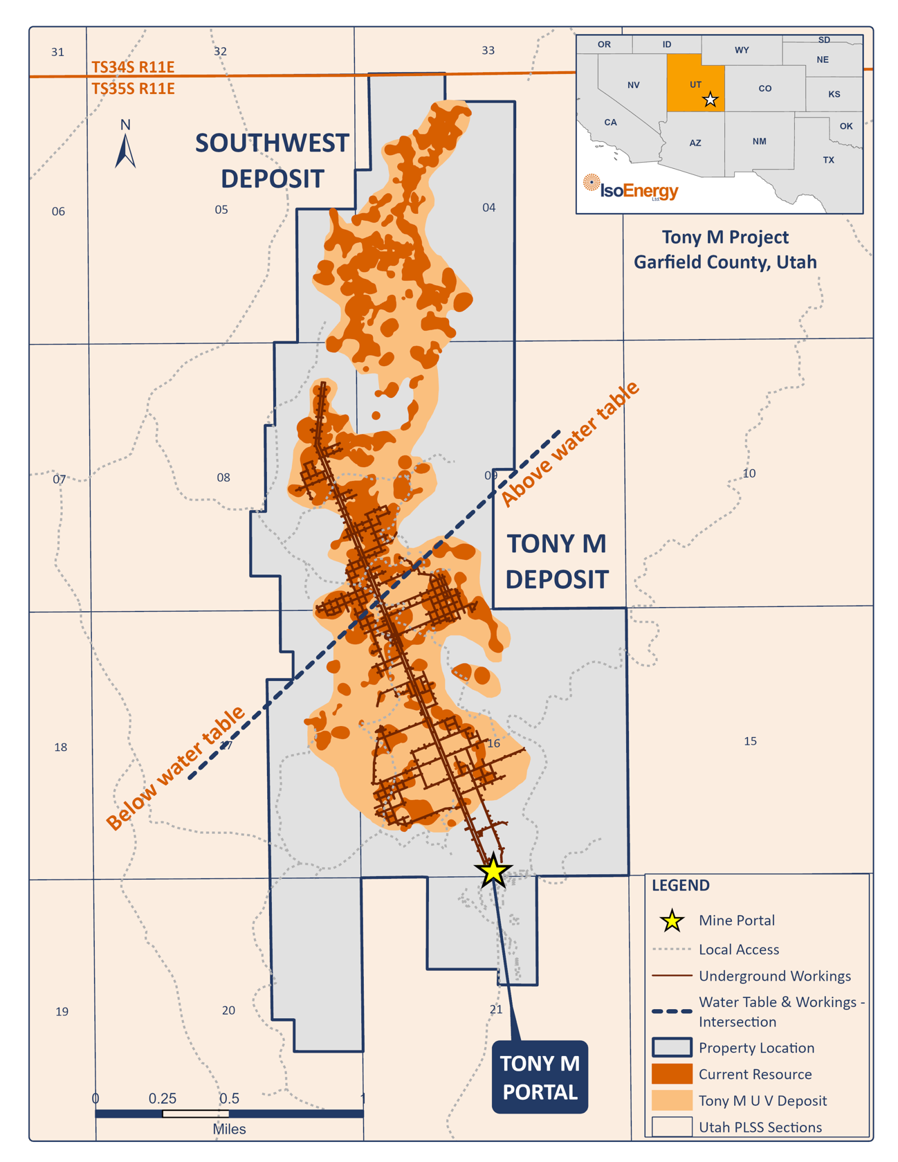
Location map of Tony M Mine showing location of the planned geophysical surveys over the known mineral resource.
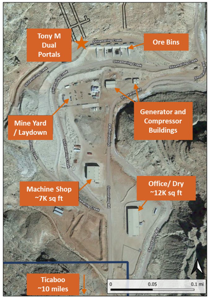
Image of large-scale surface infrastructure at the Tony M Mine, which includes two parallel declines extending 10,200 ft, a power generation station, fuel storage facility, ore bays, maintenance building, offices, dry facilities and evaporation pond.
